 Our World War II Veterans
CHAPTER 1
Background
They had come from the vast reaches of the Pacific, these men who stood offshore at Okinawa before dawn of 1945’s Easter Sunday.
The impersonal summons of strategy had gathered them from the coconut groves and kunai plains of the Solomons, the coral islands of the Marshalls, the cane fields of the Marianas, and the jungles of the Philippines. They rode with the Pacific’s largest fleet–a proud fleet which had taught the Japanese that it controlled the ocean.
A British armada guarded their south flank. To the north an American carrier task force stood poised to intercept attacks from the Imperial homeland less than 400 miles away.
The big guns of the fleet off the landing beaches scorched the haze of morning nautical twilight, and as the gunfire shifted inland more than 100 aircraft began their final runs above the beaches. The landing craft churned shoreward on a front nearly eight miles wide.
Ahead of the men in those tractors was a battle; behind them, a war. But also behind them, even if few considered it in that moment, was a finely geared combat machine precision tooled by days, months, and years of planning.
Strategic Situation1
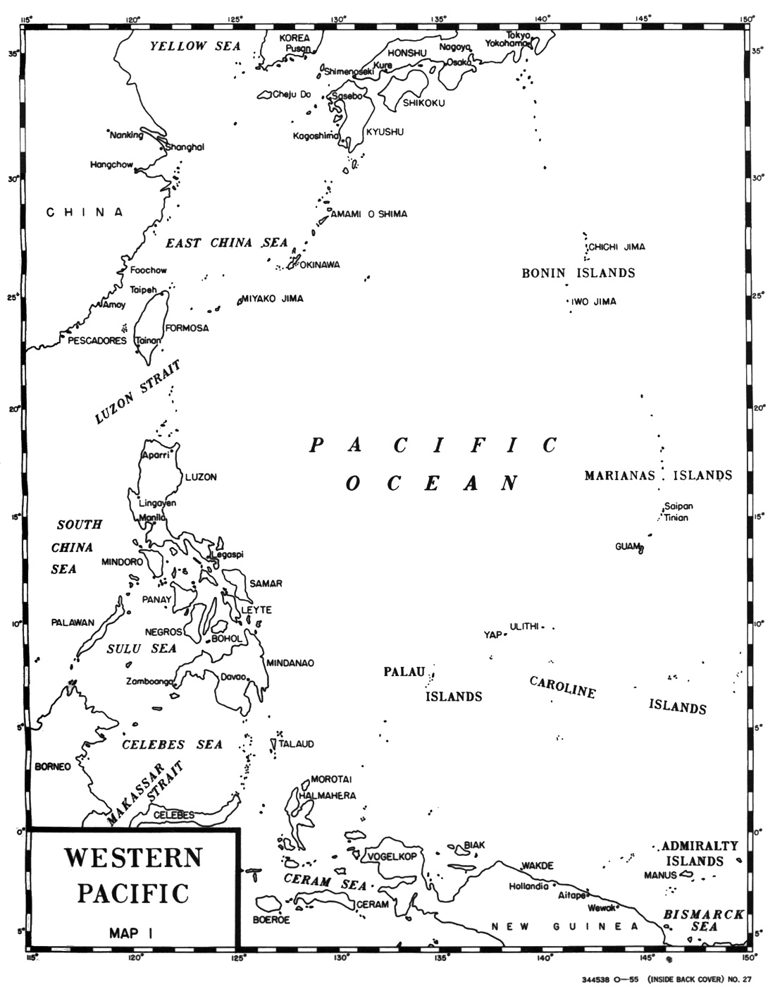
The basic strategic concept governing the offensive stages of the war with Japan was approved by President Roosevelt and Prime Minister Churchill during the Cairo Conference at the close of 1943. This concept envisioned an advance across the vast expanse of the Pacific along two principal axes of operations. The forces commanded by General Douglas MacArthur were to advance along the north coast of New Guinea to the Philippines; and Admiral Chester W. Nimitz would direct a converging drive through the Central Pacific to the core of the Japanese defenses. Accomplishment of this broad plan entailed a series of concurrent and mutually supporting amphibious attacks directed toward the Luzon-Formosa-China triangle. As required, the major combatant elements of the Pacific Fleet would cover the specific operations within both strategic commands and contain the Japanese fleet.
Implementation of this strategy resulted in an advance toward the heart of the Japanese Empire that surged forward with constantly increasing acceleration throughout the entire year of 1944. The year opened with a landing in New Guinea at Saidor. In February deep thrusts into the Central Marshalls collapsed the outer shell of Empire defenses. On the southern flank, by the end of March a permanent breach in the Bismarck Archipelago barrier had been secured and airfields and harbors seized in the Admiralty Islands. The drive up
Map 1
Western Pacific
the New Guinea coast began the following month with landings at Hollandia and Aitape. By midsummer Central Pacific forces were consolidating their hard-won footholds in the Southern Marianas after driving the entering wedge into the inner ring of Japanese island positions. At the end of July, by a series of leapfrogging envelopments, Southwest Pacific forces had advanced hundreds of miles along the northern coast of New Guinea, isolating thousands of enemy soldiers beyond hope of further effective employment. (See Map 1.)
MacArthur’s troops occupied Morotai in September, preparatory to attacking Mindanao. Simultaneously, Nimitz’ forces linked the two lines of advance by the seizure of airfield sites and a fleet anchorage in the Western Carolines. Denial of the airfields to the Japanese secured the eastern flank of the Philippine assault while possession of the anchorage, at Ulithi, was vital to both the Philippine campaign and the movement north to Japan.
When the customary covering strikes by Admiral William F. Halsey’s fast carrier forces, preliminary to the Morotai and Western Carolines operations, uncovered surprisingly weak resistance in the Central Philippines the line of advance through the Southwest Pacific veered northward. Halsey, ever aware of “the necessity of being alert for symptoms of enemy weakness and of being ready to exploit them,” recommended cancellation of certain scheduled operations and an early return to the Philippines in the Leyte-Samar area.2 Consequently, on the day that Peleliu was stormed and Morotai occupied, the Joint Chiefs of Staff made the significant decision to bypass Mindanao, cancel contemplated operations in the Carolines against Yap, and land on Leyte on 20 October.
A sound strategy implemented by careful planning, prompt exploitation of enemy weaknesses, and willingness to take calculated risks had paid high dividends throughout the year. The once formidable advance bases at Truk and Rabaul were rendered innocuous without direct assault. In conjunction with the campaigns in the Marianas and the Philippines the Japanese fleet was brought to battle and decisively defeated. The relentless depredations of American submarines added constantly to the heavy toll of enemy merchant shipping. By the end of 1944 the sea power of Japan was virtually eliminated, and the spoiling attacks of B-29’s were carrying the war to the heart of the Japanese homeland. The Allies had advanced 3,000 miles and established a strategic line 1,300 miles from Japan proper, cutting the enemy communications with their resources to the south.
Early in 1945, as Japanese strength ebbed, United States forces at long last gained a position from which a major assault could be launched against the enemy center of resistance. Luzon was invaded and the eastern strategic flank was advanced to within 750 miles of Tokyo by the capture of Iwo Jima.
By March 1945 the Pacific War had progressed far beyond all expectations of 12 months before, and with good reason Fleet Admiral Ernest J. King noted with pride the accomplishments of the preceding year in his second official report to the Secretary of the Navy. He cautioned, however, against complacency and warned of “a long, tough and laborious road ahead.”3 For as Admiral Raymond A. Spruance later said, “We were looking ahead to a prolonged operation at Okinawa, which was only 325 miles from Southern Kyushu.”4
Okinawa was the central link in a chain of islands, the Nansei Shoto, which extended in an arc from the Japanese home island of Kyushu to the Japanese-held island of Formosa. Thus anchored on these two enemy bastions, the Nansei Shoto formed an effective barrier screening the East China Sea from the North Pacific. Okinawa was a vital communication center linking Japan and its holdings to the southwest. Largest and most populous island of the archipelago, it was suitable for the development of a large number of airfields and extensive base facilities. In addition to a small harbor, it possessed the only two substantial Japanese fleet anchorages south of Kyushu.

Map 2
Okinawa Gunto
Okinawa, then, was a significant strategic objective. Its capture would secure command of the East China Sea and consequently open the approaches to the Yellow Sea and the Straits of Tsushima. Finally, it would provide a base for future operations against the Japanese homeland or the China coast.
Historical Notes5
By the irony of fate and geographical misfortune, Okinawa occupies a unique position in the history of the rise and fall of the Japanese Empire. It was the scene of the final battle of the war that destroyed the Empire of Japan; and for the same basic reason (its position in relation to China and Japan), the island figured prominently in the operations that unleashed the forces of Japanese imperial expansion–Commodore Matthew C. Perry’s expedition of nearly a century before.
The Perry voyage culminated 50 years of growing American interests in the Far East. Specifically, these interests involved trade with China and attempts to open the ports of Japan. At the beginning of the nineteenth century, the fur trade of the Pacific Northwest had provided the impetus for the promotion of trade with China; and, coincident with the decline of the fur trade in the 1820’s, the rapid rise of the whaling industry in the North Pacific stimulated a desire for “ports of refuge and supply”6 in Japan. Finally, in the second half of the 1840’s, the extension of the boundaries of the United States to the Pacific coast, accompanied by an influx of settlers to that region, spurred the expansion of American Far Eastern relations to a climax. Consequently, in 1852,
Commodore Perry was commissioned to negotiate a commercial treaty with Japan.
Fully cognizant of the difficulties involved, Perry laid his plans accordingly. Although confident of ultimate success, relatively recent experience with the reluctant Japanese cast doubt in his mind “as to any immediate success in bringing that strange government to any practicable negotiation.”7 He therefore deemed it “necessary that the squadron should establish places of rendezvous at one or two of the islands south of Japan, having a good harbor and possessing facilities for obtaining water and supplies.”8 These islands, Perry continued, in further delineation of his plans, “called the Lew Chew group are said to be dependencies of Japan, as conquered by that power centuries ago; but their actual sovereignty is disputed by the government of China.”9
This vague and anomalous status of the Ryukyus10 in respect to China and Japan was one of long standing. It persisted for 250 years preceding Commodore Perry’s arrival at Okinawa in 1853, and it continued in varying degrees another 40 years after his final departure the following year. Nevertheless, by direct negotiations with the local authorities, Perry established the proposed base at Okinawa preliminary to entering Japan.
The first foreigners to come into contact with the Okinawans were the Chinese, who initiated a series of forays into the Ryukyus in the sixth or seventh century. These raids continued
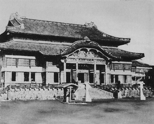 SHURI CASTLE is shown in prewar view from a captured Japanese tourist postcard. (Navy Photograph) |
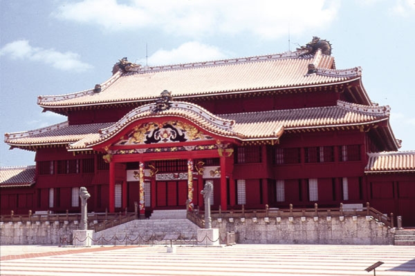 SHURI CASTLE shown today. (Courtesy of www.kenshin-kan.com) |
intermittently for hundreds of years, but the Chinese never established firm military domination. However, when a Chinese envoy demanded tribute, shortly after the accession of the Ming Dynasty in 1368, the Okinawan king promptly complied and acknowledged himself a Chinese subject.
Amicable relations existed between Japan and the Ryukyus from very early times, but the Japanese apparently obtained a certain amount of jurisdiction over the islands in the mid-fifteenth century. Positive Japanese control was established in 1609 when the Okinawan king refused to contribute men and supplies to Hideoshi’s Korean Campaigns. In reprisal, the Prince of Satsuma overran the country, devastated the land, captured the king, and exacted tribute. Henceforth, the Ryukyuan kingdom maintained a dubious semi-independent status, assenting to the dual suzerainty of China and Japan, and paying tribute to both.
The emergence of Japan as a modern power followed close on the heels of Commodore Perry’s successful negotiations, and each stage of her meteoric rise from fuedalism was accompanied by a corresponding decline of Okinawan independence. When the Mikado was restored to dominant authority in 1867 the powers of the feudal lords passed to the imperial government, and the Satsumas were forced to relinquish their control of the Ryukyus to the Foreign Office. The Japanese feudal system was

Map 3
Okinawa Shima
abolished in 1871, and shortly thereafter the Okinawan king (although permitted to retain his regal title) was installed in a residence in Tokyo as a Marquis of Japan. Three years later the islands were transferred from the jurisdiction of the Minister for Foreign Affairs to that of the Home Minister, and further payment of tribute to China by the Okinawans was forbidden.
Despite this virtually complete political integration of Japan and the Ryukyus, China still maintained adamant claims to suzerainty over the islands. The Okinawans themselves protested to the utmost the idea of single sovereignty, and complained of being “heartlessly disowned by father China.”11 Indeed, even though the Okinawan king was deposed and replaced by a Japanese governor when the islands were incorporated into Japan proper as the prefecture of Okinawa in 1879, vestiges of the old tributory relationship still remained. Not until Japan resorted to the sword in the Sino-Japanese War of 1894 was the last tenuous connection with China severed.
From 1879 onwards, through education, conscription, and careful supervision of local government, the Japanese conducted a comprehensive program aimed toward complete amalgamation of the Okinawans. The political status of Okinawa prefecture was equalized with the northern prefectures in 1920 by the establishment of a prefectural assembly and Okinawan representation in the Japanese Diet. In 1943, the domestic structure of Japan was reorganized, and Okinawa was combined with seven other prefectures into the District of Kyushu.
Okinawa and the Okinawans12
The Ryukyu Retto, which comprises most of the Nansei Shoto, includes five major island groups: the Osumi, Tokara, Amami, Okinawa, and Sakishima Guntos. Okinawa Shima occupies the central position in the Okinawa Gunto. The principal satellites surrounding the main island are: Kerama Retto, Kume Shima, Aguni Shima, and Ie Shima to the west; Iheya Retto and Yoron Shima in the north; and a chain of small islands, called the Eastern Islands by the Americans, running roughly parallel to the east coast of southern Okinawa.13 (See Map 2)
The island of Okinawa is some 60 miles in length, oriented generally northeast to southwest, and of variable width. In the north the Motobu Peninsula, jutting out into the East China Sea, extends the island to its maximum breadth of 18 miles. Similarly, the Katchin Peninsula, stretching out toward the Pacific, widens the island to 15 miles just south of the Ishikawa Isthmus. This isthmus, only two miles wide and the narrowest part of the island, separates Okinawa into two sharply contrasting regions.
The northern portion, constituting two-thirds of the island’s area, is mountainous, heavily wooded, and rimmed with dissected terraces.14 Blanketed with a dense growth of live oak and conifiers, climbing vines and underbrush, the highlands of the north rise to jagged peaks of 1,000-1,500 feet which extend the entire length of the region. Normally, the terraces bordering the spinous mountains terminate at the coast in sheer cliffs.
The shallow topsoil of the interior of northern Okinawa, principally clay or sandy loam, is well drained by numerous small, swift streams. With few exceptions, it is trafficable
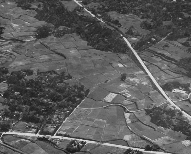
TYPICAL PATCHWORK TERRAIN of central Okinawa with its small fields, walled houses, and scattered woods appears in this pre-invasion aerial photograph. (Navy Photograph)
under all conditions, a military boon largely cancelled out by the paucity of roads, which were mainly along the coast. Furthermore, the rugged topography of the country, aggravated by the lush vegetation, precludes cross-country movement.
Excluding a limited area just south of Ishikawa Isthmus which resembles northern Okinawa, the southern third of the island is for the most part rolling, lightly wooded country broken by precipitous scarps and ravines. Four-fifths of the land is arable, and the valleys, hills, and plateaus are intensely cultivated. The hills rarely exceed 500 feet in elevation, and the few streams flowing through them are narrow and shallow. While Okinawan streams are easily bridged or forded, they are frequently rendered significant obstacles by steep, thickly forested embankments and flash floods. (See Map 4)
The densely populated south15 contained an intricate network of roads, but only one, the broad stone-paved highway connecting the cities of Naha and Shuri, could support two lanes of traffic. Although the narrow, arterial routes were surfaced with coral, other thoroughfares were no more than cart trails. Because of the drainage and soil conditions of the region, these
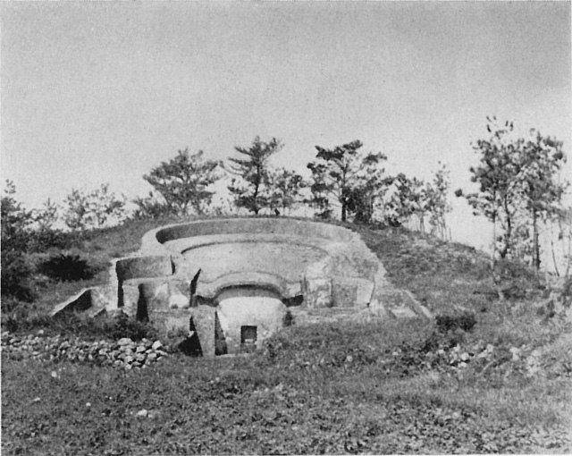
LYRE-SHAPED Okinawan tomb of the type that studded the hillsides of the island. Many of these tombs were converted into strongpoints by Japanese defenders.
primitive roads were for the most part impassable during prolonged wet weather. In the Naha-Shuri area the road net was augmented by approximately 30 miles of narrow-gauge railway. A trans-island line ran from Naha to Yonabaru by way of Kobakura and Kokuba, while branch lines linked Kobakura with Kadena and Kokuba with Itoman. In some places the track of this rail system was laid below the surface of the ground in cuts deep enough to conceal a man walking upright. (See Map 3)
Okinawa lies between 26° 03′ and 26° 52′ north latitude and 127° 41′ and 128° 41′ east longitude, and its climate is characterized by moderate temperatures throughout the year. Minimum temperatures are above 40°, with a mean maximum in July of 89°. Relative humidity, however, is high in all months, winter humidity averaging only 10% less than that prevailing in the summer.16 The year-round humidity is highest in the early morning hours and lowest in the early afternoon.
Annual precipitation is heavy and erratic, and a day’s downpour frequently equals a month’s average. In general, the heaviest rains occur from May through September. An average of almost two typhoons a month pass through the area in the season from May to November. For the remainder of the year the normal typhoon track lies well to the east of Okinawa.
In 1940 Okinawa had a population of nearly half a million. Within this community most of the higher officials, businessmen, and urban “white collar” class were main-island Japanese. The rural element, who formed the broad base of the social structure, comprised the bulk of the native populace.
On small farms, averaging little more than an acre and a half, the Okinawans cultivated three principal crops. Half the arable land produced sweet potatoes, the staple food of both men and animals. Second in acreage to the sweet potato, sugar cane constituted the principal commercial crop. Rice, the third of the group, was grown in the low alluvial coastal regions, but the yield fell far below local requirements.
Individually sheltered by stone walls or bamboo windbreaks, the small, thatched, clay farmhouses were customarily clustered in villages around an open market place. The size of these villages ranged from less than 100 to more than 1,000 inhabitants. The towns (Itoman and Nago) were substantially outsize villages with several modern business and government buildings. In the cities (Naha and Shuri) many of the public buildings were of stone or concrete construction, and the one-story wooden dwellings were surrounded by stone walls. Shuri had been the ancient capital of the Ryukyus and the citadel of its kings still stood on a high hill on its outskirts. Naha, with a population of more than 60,000, was the commercial and communications center of the Ryukyus, as well as the seat of the prefectural government.
The elected prefectural assembly acted as a gubernatorial advisory body, but the governor could accept or ignore as he saw fit any advice tendered. He could also disapprove any legislative act; and he answered for his actions only to the Home Minister, on whose recommendation he was appointed. Local assemblies also were elected in the cities, towns, and townships, the latter composed of groups of rural settlements. These local assemblies selected a mayor for towns and townships. In
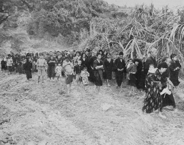
DRESS and physical appearance of typical Okinawan natives is shown in this photograph taken shortly after the Tenth Army landing.
the cities a council was elected. The local administrative units were directly under the governor, and their acts were subject to his veto. Both assemblies and councils could be dissolved by the Home Minister.
Although the Japanese educational system reduced the language barrier to some extent,17 it failed to apply to the native population more than a thin veneer of Japanese culture. Generations of direct Chinese influence stamped the Okinawans with national characteristics that could not be removed by half a dozen decades of formal education.18 The natives retained their own culture, religion, and form of ancestor worship. The outstanding material manifestations of their particular customs were the lyre-shaped tombs which thickly studded the countryside. Despite marked physical resemblance and common ethnological origins,19 the Japanese and Okinawans remained
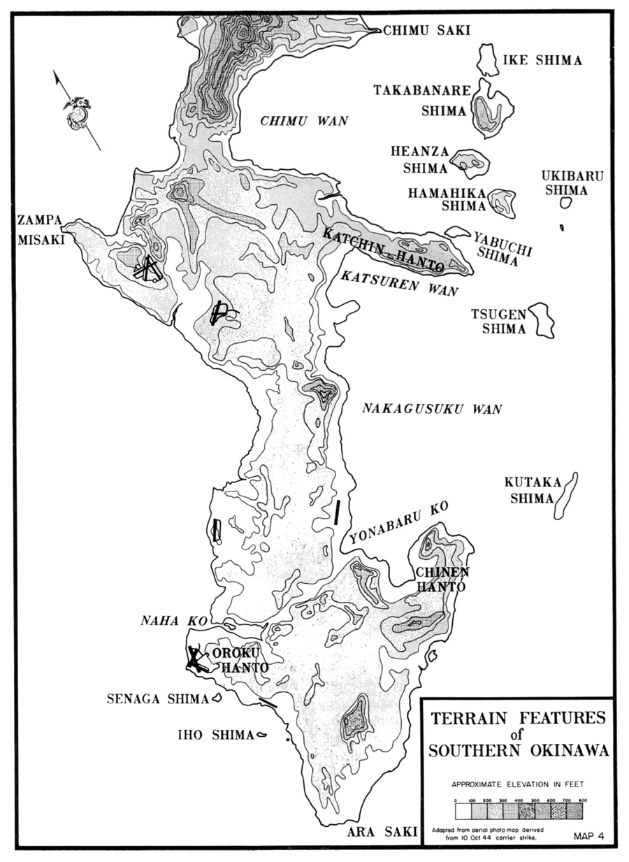
Map 4
Terrain Features of Southern Okinawa
essentially foreign to each other.20 From the native islanders standpoint, there was a deep feeling of resentment because of the social, political, and economic discrimination that existed in favor of the Japanese.21
The tacit assumption by the Japanese of the Ryukyuans’ inferior status did not prevent the imposition of one obligation of citizenship–military service. The periodic calls of various age groups into the ranks affected natives of Okinawa and the rest of the Ryukyus as well as those of Honshu and Kyushu. A reservoir of experienced reservists, who had completed their active service in the armed forces of the Empire, was available for recall. Captured Japanese orders, organization tables, and military proclamations indicate that many of these reservists were integrated into regular Japanese units assigned to the defense of the Nansei Shoto.22
Except for regular drafts of men leaving for service and the unwelcome news of those who had died for the Emperor, the early stages of the war touched the rustic life of the islands very little. The situation of the garrison on Okinawa typified the state of readiness of all the major islands of the group.
The Nakagusuku Wan Fortress Artillery Unit, whose formidable title disguised its actual lack of strength, arrived on the island in 1941. Numbering less than 600 men, organized into a headquarters and three batteries with six 75mm and two 12cm guns, the unit furnished inadequate protection to the anchorage for which it was named. For three years this organization, together with a few lightly-armed guard companies, a skeletal naval base force, and a minimum of airfield maintenance personnel, constituted the entire garrison of Okinawa Gunto.23
The importance of the Nansei Shoto to the defensive cordon surrounding Japan proper was heightened in early 1944 by the clear implication of the converging Allied pincers in the Southwest and Central Pacific. On 1 April 1944, Imperial General Headquarters set up the Thirty-second Army, with headquarters on Okinawa, to control the defense of the island chain.24 The months immediately following saw substantial reinforcements, ground, naval, and air, flow into the Thirty-second Army area. In preparation for “a show-down battle . . . for the preservation of national unity when the enemy advances to the Nansei Shoto,” the Japanese began to dig themselves into the naturally strong defensive terrain.25
Planners on both sides realized that the topographical characteristics of the islands, especially Okinawa with its wide and deep area for the deployment of troops, projected a battle on a scale as yet unseen in the Pacific. In the coming engagement the Japanese counted on concentrating “the combined force of land, sea, and air power . . . for the destruction of the enemy.”26
Footnotes
1. Unless otherwise noted the material in this section is derived from The War Reports of General of the Army George C. Marshall, General of the Army H. H. Arnold, and Fleet Admiral Ernest J. King, (Philadelphia, 1945), hereinafter cited as War Reports; USSBS(Pac), NavAnalysis Div, The Campaigns of the Pacific War, (Washington, 1946), hereinafter cited as Campaigns.
2. FAdm W. F. Halsey and LCdr J. Bryan, III, Admiral Halsey’s Story, (New York, 1947), 199.
3. War Reports, 649.
4. Adm R. A. Spruance, “The Victory in the Pacific,” Royal United Service Institution Journal,November 1946, 552.
5. Unless otherwise noted the material in this section is derived from F. L. Hawks, United States Japan Expedition by Com M. C. Perry, 3 vols, (Washington, 1856), hereinafter cited as Perry Narrative; USAFPOA G-2 Study of Okinawa Gunto, n. d., hereinafter cited as USAFPOA Study;MIS, WD, Survey of the Nansei Shoto and the Nanpo Shoto, 15Feb43, hereinafter cited as WD Survey.
6. Perry Narrative, I, 85.
7. Ibid. The American unarmed ship Morrison was fired on when private interests attempted to open Japan in 1837. The precursor of the Perry Mission, under Como J. Biddle, failed even to begin negotiations in 1846, although the Japanese did provision Biddle’s small squadron of two ships. C. Yanaga, Japan Since Perry, (New York, 1949), 16-17.
8. Perry Narrative, I, 85.
9. Ibid.
10. “A Chinese envoy, Shukan, named the islands, Loochoo [Lew Chew or Liuchiu] (or Ryuku in Japanese) as the islands resembled ‘floating globes’ or in another translation ‘precious stone balls.'” USAFPOA Study, 1. Presumably the Japanese name Ryuku or Ryukyu stems from their inability to pronounce the letter “L”. Throughout this monograph the more common spelling “Ryukyu” has been used.
11. Ibid., 3.
12. Unless otherwise noted the material in this section is derived from CinCPac-CinCPOA Bull 161-44, Okinawa Gunto, 15Nov44, hereinafter cited as CinCPOA Bull 161-44; EngrSect, FMFPac, Engineer Intelligence Information, Okinawa Shima, n.d.; WD Survey; USAPPOA Study. The terrain description presented furnishes a general picture of Okinawa at the time of the American landings before the giant earth-moving machinery of the engineers and Seabees substantially altered its appearance. Detailed studies of various sections of the island that figured prominently in the operation will be embodied in the narrative.
13. Free translation of Japanese geographical terms, regarding which there is no hard and fast rule, yields Shoto–various islands or group of islands; Gunto–a group of islands; and Shima orJima–an island. A glance at a map will show that there has been no norm followed in the distribution of these names. In this monograph wherever there has been a question regarding the proper name to use, the term in most common usage has been adopted.
14. The term “dissected terrace” refers to an area which was once essentially flat, but which has been so cut up by erosion that the high portions between ravines are the only remnants of the former flatland.
15. An area about four times as large as Guam, Okinawa was inhabited by twenty times as many people, three-quarters of whom were located in the southern third of the island.
16. The summer humidity range is 72%-90%; the winter range is 65%-80%.
17. Although the Japanese and Okinawan languages are derived from the same archaic tongue, they are mutually unintelligible.
18. At the time of the Manchu conquest of China, in the mid-seventeenth century, a number of nonconformist Chinese families fled to Okinawa. These emigres and their descendants generally became the schoolmasters of the country. Perry Narrative, I, 223.
19. Both Japanese and Okinawans stem from branches of the Ainu aborigines; however, there is a greater infusion of Mongoloid and Maylayan blood in the Okinawans.
20. A Japanese superior private, who landed on Okinawa in late 1944, after a visit to Shuri noted in his diary, that “the houses and customs here resemble those of China and remind one of a Chinese town.” CinCPac-CinCPOA Bull 147-45, Translations and Interrogations No 32, 16Jun45, Diary of Superior Pvt, 272d IIB, 43-49.
21. As the war progressed, this feeling apparently rose very near to the surface. In November 1944, a Japanese soldier recorded that “the natives bear ill feeling toward military personnel, and as the days go by, their feelings appear in their actions. This has become a very unpleasant place to live.” CinCPac-CinCPOA Bull 161-45, Translations and Interrogations No 34, 27Jun45, Diary of Signalman, 5th Sea Raiding Base Hq, 51-53.
22. Tenth Army G-2, Combat Intelligence Collecting Agency Subsection Translations Nos 4-308, 17Apr-4Jul45, hereinafter cited as CICAS Trans. See especially CICAS Trans No 83, Standards for the Establishment of Nansei Shoto Garrison Plans, 1Jan45.
23. Tenth Army G-2 Intelligence Monograph, August 1945, Part I, Sect B, 10; Part I, Sect D, Chap 1, 3, hereinafter cited as IntelMono.
24. Ibid., Part I, Sect B, 8.
25. Tenth Army G-2 Weekly Summary No 1, 28May45, Annex B, 32d Army Ord #82, 19Jul44.
26. Ibid., 32d Army Instructions, 6Aug44.