 Our World War II Veterans
CHAPTER 2
Planning ICEBERG
The fundamental principle underlying all operations of war–to project superior combat power, successively, upon the decisive points of a theater of war–is simplicity itself. The difficulty lies in recognizing these points and selecting the most favorable lines of operations. A different state of policy, strategy, and relative strength requires continual re-evaluation and revision of strategical estimates and plans. Thus, strategical plans must be kept up to date during the course of a campaign, but the extent of the field of strategy, plus the breadth of experience and knowledge of those charged with its formulation, provide ample room for honest differences of opinion. Consequently, the views of General MacArthur relative to the conduct of the war with the Japanese were often at variance with the thinking of Admiral King concerning Pacific strategy.
Strategic Concepts
In the early stages of the strategic offensive in the Pacific, General MacArthur, determined to return to the Philippines, doubted the necessity of capturing the Marianas and generally opposed the Central Pacific approach. From Admiral King’s viewpoint occupation of the Marianas was essential, the need to recapture the entire Philippine archipelago was questionable, and a drive through the Central Pacific toward the China coast, probably by way of Formosa, should constitute the main effort.1
These conflicting concepts were partially resolved by the Joint Chiefs of Staff on 12 March 1944. Admiral Nimitz was directed to land in the southern Marianas on 15 June, and attack the Palaus on 15 September 1944. General MacArthur’s instructions were to capture Hollandia in April and contemplated eventual occupation of Mindanao on 15 November. The long-range strategy outlined in the directive also required CinCPOA2 to prepare plans for an assault on Formosa early in 1945, while CinCSWPA was charged with the preparation of plans for the recapture of Luzon “should such operation prove necessary prior to the move on Formosa.”3
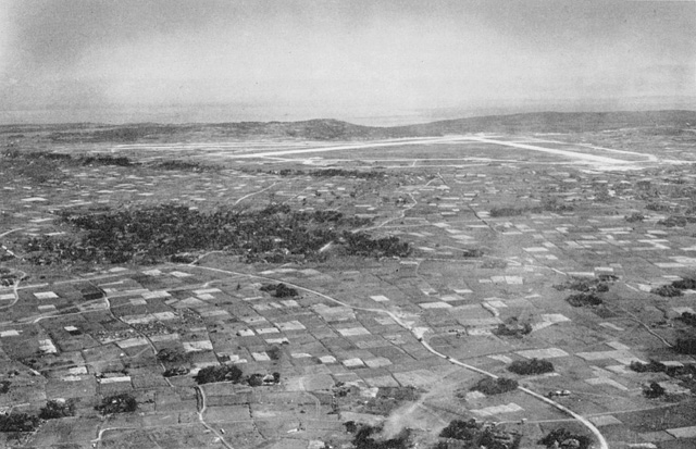
YONTAN AIRFIELD, strategic objective in IIIAC zone of action, photographed on 4 April. (Army Photograph)
As the summer of 1944 drew near, the strategy of the war against Germany had crystallized, and the Anglo-American armies in the United Kingdom were poised for the decisive cross-channel attack to “enter the continent of Europe and . . . undertake operations aimed at the heart of Germany and the destruction of her armed forces.”4 Pacific strategy still was fluid. Early in May 1944, during the lull preceding the landings in France and the Marianas, Admiral King met with Admirals Nimitz and Halsey in San Francisco to consider probable operations in the Pacific subsequent to the latter campaign.
In the discussions during this conference of the top naval command, opening sea communications with China and securing air bases in the Western Pacific were primary considerations.5 A strong Japanese drive on Chungking was in progress at the moment, which indicated a possibility that Japan might attempt to force a separate peace with China.6 Consequently, Admiral Nimitz advanced the view that establishment of positions on the China coast, in order to supply and equip the Chinese and exploit their manpower potential, appeared essential. It was envisaged that operations along the coast would progress northward as far as Shanghai, with a view to gaining river and rail access to the interior.7
In mid-June, when the lodgment in Europe had been successfully effected and concurrent with the initial landings on Saipan, the Combined Chiefs of Staff turned their attention to operations in the Pacific following the campaign in the Marianas. The possibility of bypassing the Philippines and Palaus and attacking Formosa before it could be substantially reinforced was considered. The fundamental factors involved in the selection of Formosa as
a major objective were its value as a base for very long-range (VLR) bombers, and the necessity of occupying that island in order to get supplies into China. The criterion governing the Combined Chiefs’ interchange of views was the importance of doing the unexpected. Hence, the concept of avoiding Formosa and moving directly to Kyushu, in the interests of gaining strategic surprise, was presented for study.8
While the Joint Staff planners studied the various possibilities for accelerating the Pacific war, including a direct invasion of Japan proper without reference to Formosa, the Joint Chiefs set up a tentative schedule of operations for planning purposes. Based on the hypothesis that all operations preliminary to the Formosan campaign, which were contemplated in the directive of 12 March 1944, had been consummated, an over-all concept of operations subsequent to the capture of Formosa was projected. It envisaged advances into the Bonins and the Ryukyus, in concert with a continuing operation along the southeast coast of China northward from Amoy. These operations were to begin about 1 April 1945 and the positions gained in these areas consolidated by the end of September, preparatory to assaults on Kyushu and the Tokyo Plain which were to be undertaken before the close of the year.9
When President Roosevelt visited Pearl Harbor in the latter part of July 1944 to confer with Admiral Nimitz and General MacArthur, the decisive campaign for the southern Marianas was drawing to a close, but the next major move toward defeat of Japan still was unresolved. Consequently, at this meeting the two theater commanders presented their differing views to the Commander in Chief for decision.
MacArthur contended that a major attack against the Japanese in territory north of Luzon should not be attempted until the Philippines had been occupied. Moreover, he was of the opinion that, except for landing craft and naval support, the resources already available to him were sufficient to recapture the Philippines. The Navy plan developed by Nimitz proposed “by-passing the Philippines and attacking Formosa.”10 However, during the discussions, the naval commander agreed that future developments might indicate a need to occupy Luzon, although at the time he felt that other areas in the archipelago offered equal advantages and could be taken at less cost. Admiral Nimitz believed his forces were sufficient for either the Luzon or Formosa operations, and the area of disagreement was finally narrowed down to the desirability of retaking the Manila area.11
A tentative course of action evolved by the Joint Chiefs of Staff in September contemplated the following schedule of operations: Talaud, 15 October 1944; Mindanao, 15 November 1944; Leyte-Suriago Area, 20 December 1944; and either the invasion of the Formosa-Amoy Area on 1 March 1945 or Luzon on 20 February 1945. In the event the Formosa operation materialized, it was anticipated that the subsequent schedule would include the Bonins in April and the Ryukyus in May. Operations along the China coast during the period of March to June were proposed, with the invasion of Japan proper to begin in October.12
Shortly after this tentative plan was promulgated, Lieutenant General Millard F. Harmon, Commanding General, Army Air Forces, Pacific Ocean Areas (CGAAFPOA), submitted a plan to Admiral Nimitz proposing that the Formosa operation be abandoned in favor of the Bonins and Ryukyus. It envisaged the capture of Iwo Jima by 1 January 1945 and the reconquest of Luzon by 1 June 1945. Concurrent with the operations of Southwest Pacific forces on Luzon, Pacific Ocean Areas troops were to seize Okinawa and Amami-O-Shima in the Ryukyus. Kyushu would be invaded in September.
Although offered as an alternative in the event that Campaign Plan CAUSEWAY (Formosa) should not be implemented, the compelling arguments with which General Harmon supported the proposed change of strategy clearly indicated that the concept of bypassing Formosa was not only practicable but also desirable. The burden of the theater air commander’s discussion was a comparison of the relative utility of Formosa and the Marianas for the conduct of air operations against Japan.
General Harmon noted that the distances from Formosa and the Marianas to Japan were approximately equal, but the geographical situation of Formosa produced inherent disadvantages militating against its usefulness as a base for long-range air operations. The plans then current provided for only partial occupation of the island–the southwestern portion. Inasmuch as the prevailing winds were from the north, heavily loaded B-29’s taking off would be exposed to hostile antiaircraft-fire when most vulnerable. Along the entire route to targets on Honshu, through the Ryukyuan chain and across Kyushu, the flights could be easily tracked and intercepted. These obstacles would be avoided in making strikes from the Marianas, especially after the capture of Iwo Jima and the establishment of bases there for fighter escorts. Finally, more favorable flying weather prevailed between the Marianas and Honshu.
Surveys of the Marianas indicated potential bases for 24 B-29 groups. Construction of these facilities promised a task of considerable magnitude, but comparable development of Formosa entailed an even greater undertaking. Besides the formidable task of developing the area, logistic support of Formosa would be considerably more complicated and its initial occupation costly and time consuming.
From the standpoint of over-all strategy, General Harmon believed that the capture and use of Luzon was essential, and that engaging in major operations on Formosa would decelerate the momentum of the advance against the Japanese Empire. Air operations from Luzon could neutralize Formosa and effectively cut enemy communications to South China and Malaya.13
When invasion of the Palaus brought Central Pacific forces up on the northern flank of the Southwest Pacific theater and closed this gap in the front, strategy in the Pacific began to crystallize rapidly. The single moot question remaining from the Commander in Chief’s conference with the two theater commanders was resolved by the tactically bold and strategically brilliant decision to begin the Philippine invasion at Leyte rather than Mindanao.14
This momentous decision, accompanied by a firm directive to enter the Central Philippines two months earlier than had been tentatively planned, gave occasion for immediate re-examination of the objectives of the Formosa operation in the light of the changed situation.
Formosa had been selected as an objective for the purposes of bombing Japanese industry; opening sea and air communications to the China Coast, while denying the same to the enemy between the Empire and the resources to the south; supporting a further advance into China; and maintaining “unremitting military pressure against Japan.”15
Over and above the questionable worth of Formosa as a base from which VLR bombers could be launched against the enemy homeland, the acquisition of the anchorage facilities of Leyte suggested the possibility of an advance northward, without securing intermediate positions on the China Coast. Occupation of Iwo Jima and Okinawa would be accomplished as
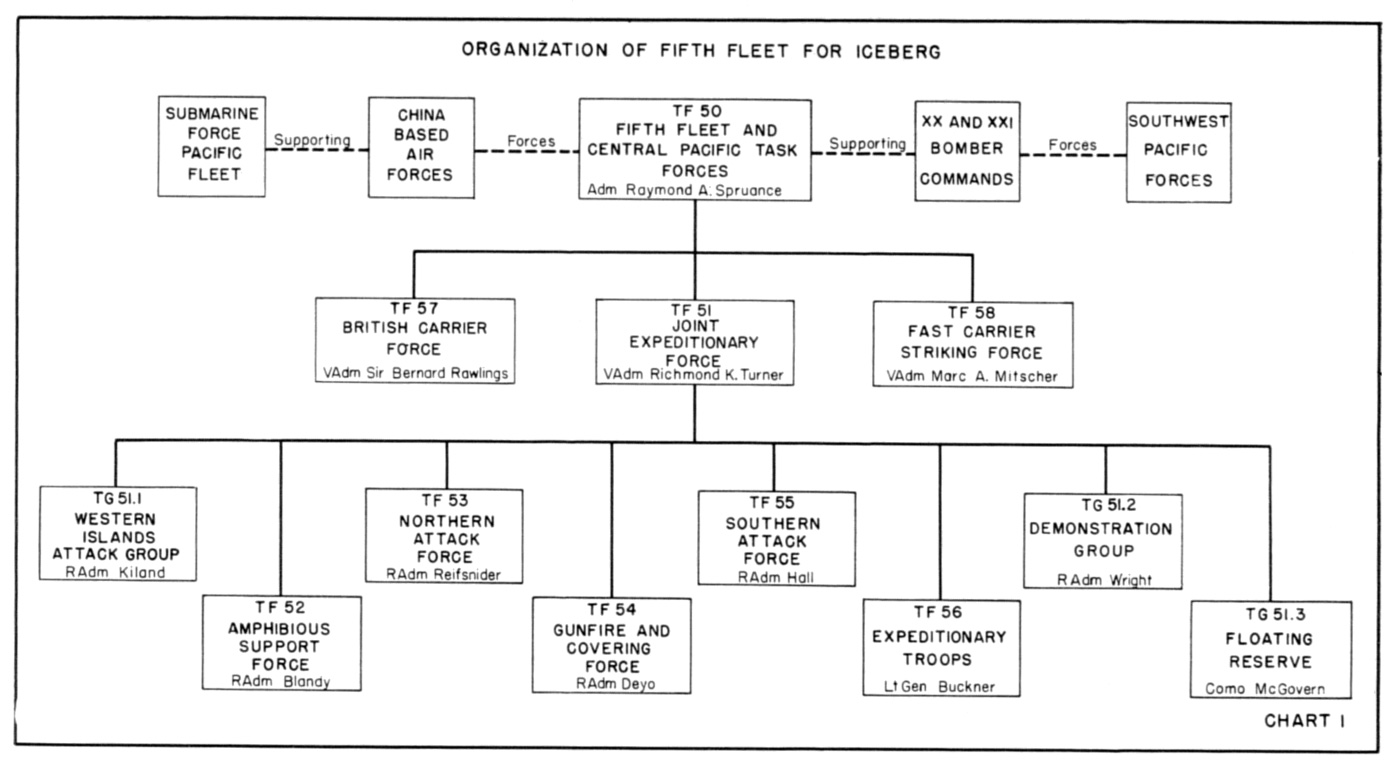
Organization of Fifth Fleet for ICEBERG
soon as practicable after CAUSEWAY. The necessity of opening communications to the coast of China was nullified further by the success of recent Japanese offensives against the Chinese. This implied the ineffectiveness of China’s forces and rendered doubtful the expediency of attempting to support a Chinese land campaign.
In view of a possible reorientation of strategy which would shift the direction of advance northwards toward Japan, Admiral Nimitz directed the principal CAUSEWAY commanders, Admiral Raymond A. Spruance, Vice Admiral Richmond K. Turner, and Lieutenant General Simon B. Buckner, Jr., to recommend suitable physical objectives in the Formosa-Amoy-Pescadores areas for the CAUSEWAY Operation. Guiding considerations were the number of naval and air bases which should be established and the number of major troop units required.16 Ten days later General Buckner replied that sufficient troops were not available and CAUSEWAY was not feasible.17 Within hours of Buckner’s reply Lieutenant General Robert C. Richardson, Jr., Commanding General, United States Army Forces Pacific Ocean Areas (CGAFPOA), who had also been invited to express his views, forwarded his remarks indicating that operations in the Formosa area were also undesirable.
General Richardson reiterated General Harmon’s objections to Formosa as a B-29 base and agreed that possession of Luzon negated the need for occupying Formosa. From the ground forces point of view, an advance along the coast of China would contribute very little toward the prosecution of the war. Since the seizure of Formosa was for the purpose of supporting a further advance into China, he concluded that the capture of Formosa was unnecessary. On the other hand, the facilities which would be gained by possession of Luzon, together with the bases which it would be possible to obtain in the Ryukyus and the Bonins offered “unusual advantages for the rapid advance on the final objective, and prosecution of the war.”18
Admiral Spruance, who also favored the capture of Iwo Jima and Okinawa rather than Formosa, has described his part in the formulation of the strategy of the Okinawa operation as follows:
When Admirals King and Nimitz visited Saipan about 12 July 1944–shortly after the end of organized
resistance–Admiral King asked me for my ideas on my next operation. At this time the Philippines campaign had not yet been definitely decided upon, but I expected to be relieved by Admiral Halsey after the completion of the Marianas operation, which still involved the capture of Guam and Tinian. My reply to Admiral King was that I would like to take Okinawa.
Before I arrived back in Pearl Harbor in the Indianapolis about 4 September 1944, I gave considerable thought to the question of the next operation for the Fifth Fleet. I came to the conclusion that Okinawa was the proper objective, but that Iwo Jima would have to be captured first. On reporting to Admiral Nimitz, he informed me that my next operation would be Amoy and Formosa. I then recommended that we take first Iwo Jima and then Okinawa instead, but was told that the decision had already been made for Formosa, and that, as soon as I was ready, I should fly to California for about two weeks’ leave.
Shortly before I was due to return to Pearl Harbor, I received orders to delay and to attend the CominCh-CinCPac conference in San Francisco about 28 September. It was at this conference that Admiral Nimitz recommended to Admiral King the substitution of Iwo Jima and Okinawa for Amoy and Formosa. This change was necessary because General Buckner had said he did not have enough service troops for an objective as large as Formosa, but he could handle Okinawa. The Marines had said they could take Iwo Jima. The paper submitting Admiral Nimitz’ recommendations for the change was, I believe, prepared by his War Plans Officer, Captain Forrest Sherman. It was the clear and logical presentation needed to overcome Admiral King’s strong belief in the value of Formosa.19
Thus, by 1 October 1944 Admiral Nimitz had conferred with Admiral King and apprised him of the views of his senior commanders in the Pacific. On the basis of this consultation, King proposed a course of future action in the Pacific to the Joint Chiefs of Staff.20 Whereupon the Joint Chiefs directed General MacArthur to seize and occupy Luzon on 20 December 1944 and Admiral Nimitz to effect a landing on Iwo Jima 20 January 1945. These were to be followed by Operation ICEBERG, the Okinawa campaign, on 1 March 1945.21 The date for the Okinawa landing, however, depended on securing Iwo Jima in time to release fire support units and close air support for Okinawa; prompt release of supporting naval forces and assault shipping from Luzon; and whether preliminary strikes against the Ryukyus, Formosa, and the Empire promised indisputable control of the sea and air in the objective area.22
CAUSEWAY was held in abeyance as a strategic objective for possible future implementation.23The fundamental command and organization concepts which had been devised for that operation were retained for employment at Okinawa.24
Command Relationships25
The command relationships, which had hitherto been prescribed in the Central Pacific for the seizure of small land areas far removed from Japan required modification for the Okinawa campaign. The amphibious operations which had carried Admiral Nimitz’ forces across the Pacific had required relatively few ground forces,26 but now the establishment of one or more positions in the Ryukyus called for the employment of a field army. Proximity of the objective to the Japanese homeland and major enemy bases presaged a prolonged period of active combat.
Admiral Spruance, Commander Fifth Fleet, was designated as the implementing commander of the operation, under the strategic direction of Admiral Nimitz, Commander in Chief,
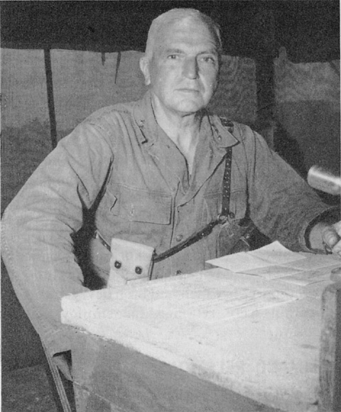
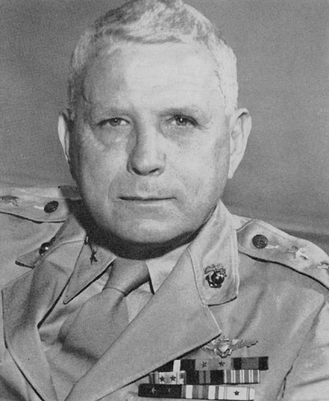
LIEUTENANT GENERAL SIMON B. BUCKNER, Commanding General, Expeditionary Troops (Tenth Army), in the Okinawa operation. General Buckner was killed in action just prior to the successful ending of the campaign. (Army Photograph)
Pacific Ocean Areas.27 Command of the Joint Expeditionary Force devolved upon Admiral Turner, Commander, Amphibious Forces Pacific Fleet. General Buckner, Commanding General, Tenth Army was assigned the status of Commanding General, Expeditionary Troops for the amphibious phase of the operation. (See Chart 1)
The principal units included in the Joint Expeditionary Force (TF 51) were: the Amphibious Support Force (TF 52), Rear Admiral William H. P. Blandy; the Gunfire and Covering Force (TF 54), Rear Admiral Morton L. Deyo; the Northern Attack Force (TF 53), Rear Admiral Lawrence F. Reifsnider; and the Southern Attack Force (TF 55), Rear Admiral John L. Hall, Jr.
Within the amphibious forces, major elements of the Expeditionary Troops (TF 56) were allotted as follows: III Amphibious Corps (IIIAC), Major General Roy S. Geiger, as the landing force of the Northern Attack Force; and XXIV Corps, Major General John R. Hodge, as the landing force of the Southern Attack Force. In addition, the 77th Infantry Division (Major General Andrew D. Bruce) and the 2d Marine Division (Major General Thomas E. Watson) were assigned as the landing forces of the Western Islands Attack Group under Rear Admiral Ingolf N. Kiland, and the Demonstration Group of Rear Admiral Jerauld Wright, respectively. (See Chart 2)
Land-based air support for the operation was to be furnished by Tactical Air Force (TAF), Tenth Army under Major General Francis P. Mulcahy, whose initial squadrons were to be mainly elements of his own 2d Marine Aircraft Wing. The 27th Infantry Division (Major General George W. Griner, Jr.) composed General Buckner’s floating reserve, and the 81st Infantry Division (Major General Paul Mueller) was designated area reserve under Admiral Nimitz.
Initial planning anticipated that the ships of the Amphibious Support Force and the Gunfire and Covering Force would assemble at and sortie from Ulithi. Following the departure of these task forces from the fleet anchorage, original plans contemplated that the commander of the Gunfire and Covering Force would be responsible for the movement and approach to the target and act as Senior Officer Present Afloat (SOPA) upon arrival in the objective area, while responsibility for the execution of all operations at the objective would devolve upon Commander, Amphibious Support Force.28 Unless delegated to a task fleet commander, the responsibility for the sea areas to the north and west of the forward
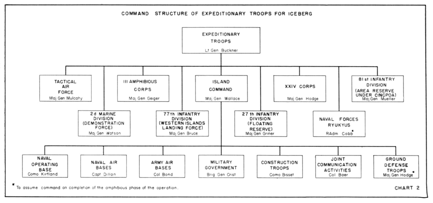
Command Structure for Expeditionary Troops for ICEBERG
zone of the Central Pacific Area rested with CinCPOA.
Upon completion of the amphibious operations at each objective and when directed by Commander, Fifth Fleet, the Commanding General, Tenth Army would assume command of all forces ashore. Thenceforth the latter would be responsible to the former for the development and defense of captured positions. Directives promulgated by Headquarters, Pacific Ocean Areas, would govern the organization and administration of the area and defense forces under the Commanding General, Tenth Army.
As the campaign progressed, and when warranted by the situation, Admiral Nimitz would relieve Admiral Spruance of responsibility for the development and defense of the Ryukyus, and assign that function to General Buckner. The Commanding General, Tenth Army would then be directly responsible to CinCPOA for the island positions and surrounding waters within a radius of 25 miles.
Plans for the garrison phase contemplated three principal implementing commanders for General Buckner in the development and defense of the captured bases: A general officer of the Army Ground Forces assigned as Island Commander, Okinawa;29 a flag officer of the Navy in command of the local naval defense forces; and a general officer of the Marine Corps in command of a joint air task force designated Tactical Air Force, Ryukyus. Strategic air forces and naval search squadrons based in the Ryukyus would operate normally under the control of CGAAFPOA and the Commander, Fifth Fleet respectively.
Long-range planning envisaged direct liaison between the Commanding General, Tenth Army and the strategic command of the Pacific Ocean Areas in the preparation of plans for operations subsequent to the Okinawa campaign. During the planning for ICEBERG, however, the Tenth Army Commander was authorized to deal directly with the Commander, Amphibious Forces Pacific Fleet, who would command the Joint Expeditionary Force.
Intelligence
In order to establish a firm planning base and ensure a common frame of reference within which each Expeditionary Troops staff section could confer with its naval counterpart, Tenth Army intelligence was closely coordinated with that of the Pacific Fleet’s Amphibious Force. For the most part, the intelligence produced throughout the planning of ICEBERG was derived from detailed studies of aerial photographs, interpreted and evaluated in
MAJOR GENERAL ROY S. GEIGER, Commanding General, III Amphibious Corps at Okinawa.
conjunction with enemy information collected by other regular intelligence agencies.
But when photographs were needed to initiate planning, the nearest Allied base was some 1,200 miles from the objective area, reducing the agencies capable of performing photographic missions to B-29’s and carrier air. Beyond this initial handicap, the hazy weather common to the Ryukyus restricted the effectiveness of the B-29 missions, and reconnaissance by carrier planes was of necessity contingent upon the scheduling of carrier strikes. These difficulties were compounded further by the vast area to be photographed.30
The initial mapping mission was flown by B-29’s on 29 September 1944. It covered all of Okinawa and its outlying islands to a limited degree. However, about half the area covered, chiefly in the northern portion of the main island, was obscured by cloud cover.31 Because of inadequate photographic coverage, the original map unfortunately included a considerable amount of “unknown” area. Subsequently, these blank spaces were filled in with contouring taken from captured Japanese maps; but the final map, based on aerial photography, was not completed and issued until midway through the campaign.32
The scale of the basic planning map was 1:25,000, from which 1:10,000 maps of the initial zones of action were prepared for the benefit of the lower units. Small-scale maps were produced for use as road maps and in traffic circulation planning.33
Rubber relief maps of 1:10,000 scale were issued to III Amphibious Corps by Tenth Army in sufficient quantity for distribution down to assault battalions. In addition, plaster terrain models of the Corps zone of action were prepared by the III Amphibious Corps relief mapping section in conjunction with those of the 1st and 6th Marine Divisions. These models were to a scale of 1:5,000, constructed with a 2:1 vertical exaggeration to facilitate the briefing of commanders and troops for prospective operations over unusual terrain against intricate defenses.34 Final distribution of these reliefs was made after embarkation, at which time the 1st Marine Division also issued some 600 copies of a special 1:5,000 map of the landing beaches.35
Large-scale vertical and oblique photographs, covering 90 per cent of the Okinawa Gunto and suitable for detailed study, were acquired during the fast carrier strike of 10 October 1944. Thenceforth partial coverage
was obtained at least once a month36 until the week immediately preceding the main landing, during which reconnaissances were flown daily by photographic planes based on escort carriers (CVE).37 Although many enemy installations were concealed eventually by effective camouflage, they were easily located by reference to early photographs. Careful study of successive sorties enabled photo interpreters to determine displacement of defense positions and changes in their relative strength,38 and to compile a preliminary Japanese battery list which was disseminated to all artillery units within the III Amphibious Corps.39
The initial intelligence estimate set enemy strength in the Okinawa Gunto at 48,600. Of this number, two first line infantry divisions and a tank regiment were believed to constitute both the hard core and the major portion of the garrison.40 The over-all estimate presented by G-2, Tenth Army in early January 1945 assumed that the enemy could reasonably reinforce the Okinawa garrison to 66,000 by the target date, this figure to include two and a half infantry divisions. If the enemy exerted his maximum reinforcement capability, it was calculated that the defense forces could be increased to 87,000 men, with four infantry divisions constituting the principal combat elements.
Enemy troop dispositions, studied in the light of Japanese tactical doctrine as it had evolved throughout the course of the war, indicated that they would most likely organize the southern third of the island for a defense in depth and withhold the bulk of their troops in mobile reserve. Besides conforming to current enemy combat principles, this course of action was also potentially more dangerous to the assaulting forces than the alternative of a determined defense at the water’s edge.41
By 1 February 1945 the enemy situation on Okinawa appeared to be roughly analogous to that which had obtained on Guam, where a single battalion composed the entire garrison of the northern sector. Photographic interpretation revealed evidence that the force on Okinawa comprised two infantry divisions and an independent mixed bridgade, reinforced by service and supporting units to bring the estimated strength to 56,000-58,000 troops. In the main these forces were concentrated to the south in the XXIV Corps area. Apparently two infantry regiments–some six or seven thousand men who could conceivably be augmented to a total force of almost 15,000 by local auxiliary troops–were located in the Marine zone of action.
While counterattacks by the small garrison in the north against the left flank of the corps were considered likely, the most violent enemy reaction was expected to materialize from the south in the XXIV Corps zone, where it was surmised that a mobile reserve of considerable size would be maintained. It was anticipated that the enemy would commit this reserve to a counteroffensive as soon as he had clarified the dispositions of the landing force.42
Information available in mid-February indicated that a full division had been withdrawn from Okinawa, and the estimated Japanese strength there was revised downward to 37,500-39,500 men. Consideration of this over-all reduction in strength, together with indications that the enemy was concentrating in the Nakagasuku Wan area, led to a presumption that no more than one infantry regiment would be available to the enemy for deployment in the III Corps zone and the total number of Japanese in the sector would not exceed 10,000.43
A month later the strength of the Okinawa garrison was reassessed upward to 64,000. The Japanese had apparently been reinforced by an
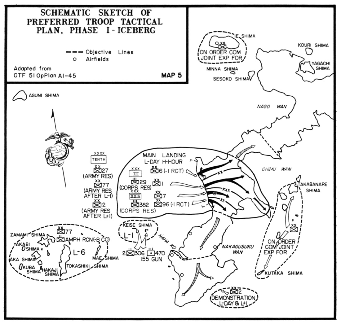
Map 5
Schematic Sketch of Preferred Troop Tactical Plan
Phase I–ICEBERG
understrength infantry division and miscellaneous units, amounting to about 20,000 troops. An additional four to six thousand men were believed to have been lifted by subsequent shipping arriving in March. If the March arrivals were the advance elements of another division, it seemed reasonable to expect that the landing force would be opposed by at least 75,000 men on the target date–L Day. By the time the leading naval units had sortied for the target, the garrison in the III Amphibious Corps zone was estimated at 16,000 of which the principal enemy strength was believed to be embodied in two reinforced infantry regiments.44
Tactical Planning
Despite the fluctuating enemy order of battle and the cogent arguments questioning the feasability of the preferred landing plan, the scheme of maneuver initially deemed the most acceptable withstood the test of continued re-evaluation and remained virtually unchanged. After being subjected to critical examination over an extended period, the scheme of maneuver executed in the spring of 1945 was essentially the preferred plan of the fall of 1944.
The earliest planning was based on the assumption that carrier attacks on Japan, long-range air operations from the Marianas, and the seizure of Iwo Jima would force a concentration of enemy air strength in the heart of the Empire. It could be expected that the Japanese would react violently to an invasion of the Ryukyus by subjecting the expeditionary forces to heavy aerial attacks staged through Kyushu and Formosa. The scheme of maneuver was therefore “designed to gain early use of sufficient airdrome capacity on Okinawa, together with unloading facilities adequate to support its development, to maintain positive control of the air in the area.”45
The guiding conception of operations in the Ryukyus was that of a campaign conducted in three major stages. Because it was the most susceptible to the construction of airfields and the development of port facilities, seizure of the southern portion of Okinawa and the neighboring small islands was to constitute the first phase; Ie Shima and the remainder of Okinawa would be secured during the second; and the positions thus gained would be exploited in the final phase by the capture of additional bases in the archipelago.46 However, eventual tactical developments reversed the sequence of the first two phases and later logistical considerations negated the reasons for the third.47
After a searching study of all beaches in southern Okinawa, the west coast beaches lying to the north and south of Hagushi appeared to be the most practicable landing area. Moreover, an initial landing in this area promised a most significant advantage: the early capture and development of the Yontan and Kadena airfields lying directly behind the Hagushi beaches. Accordingly, a plan which committed the assault divisions to the western beaches was prepared and recommended as the most favorable course of action. This scheme also provided for the pre-L Day seizure of Keise Shima where artillery could be emplaced to augment the fires of naval guns supporting the main landing. (See Map 5)
This concept was presented to the combined naval and landing force staffs on 1 November 1944, at which time Admiral Turner presented his views. He held that the adjacent islands should be neutralized and an anchorage secured near Okinawa for the logistic support of the fleet. Because of the unfavorable weather prevailing in March, the admiral was apprehensive of an attempted landing in the west during that season and requested that the possibilities of a landing on the east coast be explored.48
After general discussion of the problem, it was agreed that a landing on the western beaches on 1 March would involve considerable risk, and that the landing should be made on the east coast or the western landings should be delayed at least 30 days. After a re-examination of the possible courses of action, the Hagushi landing was again recommended and on 6 November the initial estimates and overlays were forwarded to all major headquarters to initiate planning.
Still dubious as to the practicality of landing and supporting the planned assault force of four divisions over the Hagushi beaches, Admiral Turner withheld final approval. Another detailed study was made on 9 November which supported the original recommendation. This time, Admiral Turner accepted the plan, provided that both Kerama Retto and Keise Shima were captured prior to a landing on Okinawa. With minor exceptions, General Buckner concurred in the modifications. Within a month, because of difficulties in maintaining shipping schedules as well as potential unfavorable
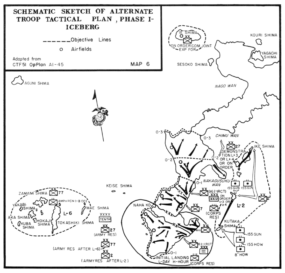
Map 6
Schematic Sketch of Alternate Troop Tactical Plan
Phase I–ICEBERG
weather, the target date (L-Day) was successively deferred to 15 March and finally 1 April 1945.49
When it was first decided to use the Kerama Retto as a protected anchorage for rearming and refueling the bombardment ships, only amphibious raids to destroy enemy coastal guns were considered. A subsequent proposal by
Admiral Turner to establish a permanent seaplane base and a small boat pool in the Keramas resulted in plans to secure each of these islands. Further studies in relation to the capture of the Keramas and Keise Shima indicated it was a task for a division, and the 2d Marine Division was initially designated as the landing force.
As planning progressed and an early commitment of the 2d Division in support of operations on Okinawa was foreseen, the 77th Infantry Division was selected for the Kerama-Keise operation and the 2d Division tentatively assigned to implement Turner’s idea of a feint landing off southeastern Okinawa.50 In response to a request for the release of an area reserve division to replace the 77th Division, the 27th Infantry Division was designated Expeditionary Troops floating reserve and the 81st Division assigned as an area reserve division.51
The alternate plan adopted for the operation made no change in the assigned mission of the 77th Division to seize the Kerama Retto preliminary to landing on Okinawa, but it committed the main effort to the east coast beaches. It further provided for the capture of the Eastern Islands by the 2d Marine Division 48 hours in advance of the principal landings so that corps artillery could be emplaced to support both corps in the assault on Okinawa. The III Amphibious Corps would land on L-Day across the Minatoga beaches (against which the preferred plan called for demonstrations by the 2d Marine Division) and gain contact at Yonabaru with the XXIV Corps, which would probably land on L-plus 2. Both corps were to advance across the island as rapidly as possible and capture the airfields in their assigned zones of action. Feints against the Chimu Wan area were contemplated on L-plus 3 or 4. The plan also provided for the capture of Ie Shima and the commitment of Army reserves to either of the corps zones or on the northern flank of the XXIV Corps.52 (See Map 6)
A tentative operation plan was issued by Tenth Army on 6 January 1945,53 with instructions that it would be placed in effect on order of Commanding General, Tenth Army. This was done on 11 March 1945, concurrent with the briefing of Fifth Fleet units which had been actively engaged against the enemy at Iwo Jima and had had little time to prepare for the Okinawa operation.54
The operation order directed XXIV Corps to land with two divisions abreast on the beaches south of Hagushi; 96th Division (Major General James L. Bradley) on the right, less one regiment in corps reserve; 7th Division (Major General Archibald V. Arnold) on the left with one regiment in division reserve but under the operational control of Commanding General, XXIV Corps. On order of the Commanding General, 77th Division, one field artillery group of XXIV Corps Artillery was to be landed on Keise Shima prior to L-Day to support the attack on Okinawa. The group would revert to control of Commanding General, XXIV Corps upon his arrival in the objective area. The remainder of XXIV Corps Artillery (Brigadier General Josef R. Sheetz) would land on corps order and support the corps attack with long-range interdiction, counterbattery, and harassing fires.55
Simultaneously, the III Amphibious Corps was to land with two divisions abreast on the beaches north of Hagushi and move rapidly inland, coordinating its advance with XXIV Corps. The 1st Marine Division (Major General Pedro A. del Valle) was to assist the 6th Marine Division (Major General Lemuel Shepherd, Jr.) in the capture of Yontan airfield by quickly seizing the high ground northeast of Chimu; thereafter, it was to continue the
attack, making the main effort on the right to maintain contact with XXIV Corps and assist its advance.56 The 1st Marine Division scheme of maneuver placed the 5th and 7th Marines in assault with the 5th Marines on the right. The 1st Marines remained in division reserve.57
The 6th Marine Division, less the 29th Marines, would land on the left of the 1st Marine Division. The 4th Marines, less the 2d Battalion in division reserve, would be on the right and the 22d Marines on the left. The division was charged with the initial mission of capturing Yontan airfield and protecting the northern flank of the Tenth Army.58 The 29th Marines in corps reserve, in addition to being prepared to land on designated beaches, would stand ready to revert one battalion landing team (BLT) to the 6th Marine Division on order. IIIAC Artillery was to land on corps order to support the attack, and once ashore to coordinate field artillery, air support, and naval gunfire in the Marines’ area.59
For the initial phase of the operation, following the landing, the objective area consisted of that part of the island lying south of a general line across the Ishikawa Isthmus running through Chimu and including the Eastern Islands. To isolate the objective, the isthmus was to be seized quickly by IIIAC in order to block enemy reinforcement from the north. At the same time XXIV Corps was to secure a general east-west line through Kuba Saki to seal off the Japanese in the south. After the capture and occupation of central Okinawa, the attack would continue to the south to secure the remainder of the objective.
Upon the completion of Phase I, the second phase was to be executed when directed by General Buckner with troops locally available. This involved the seizure of Ie Shima and the rest of Okinawa. It was contemplated that Motobu Peninsula in the north of the island would be secured by means of a combined shore-to-shore amphibious and land assault, followed by a shore-to-shore attack against Ie Shima. The capture of the rest of northern Okinawa would bring the end of Phase II.60
Although many of the supporting naval units assigned to ICEBERG had been given little respite between operations, the fact that they had participated in the capture of Iwo Jima simplified planning to a certain extent. Command and communication arrangements of TF 51 were tested and proven at Iwo Jima and modified as required by the peculiar circumstances of operations at Okinawa.
The particular difficulties expected at Okinawa involved several new factors. For the first time in the Pacific, four divisions were to land abreast on a front of almost 10,000 yards. This extended beach frontage, coupled with the offshore navigational hazards, limited the density of fire which could be provided by the support ships. In addition, a considerable number of coastal guns had to be destroyed before ships could close to a range from which they could deliver the most effective fire against enemy defenses opposing the landing. A large portion of the selected beaches were backed by extensive sea walls, which it would be necessary to breach in order to provide exits for combat vehicles. Detailed knowledge of the Japanese defensive dispositions in relation to the beaches was lacking, and the enemy possessed the capability of moving major units within a few hours to contest any attempted landing, unless continuous interdiction was maintained on a large number of roads.61
Naval gunfire officers of the 1st and 6th Marine Divisions, III Amphibious Corps, and the Northern Attack Force established early liaison. Priority naval gunfire targets were
selected by the divisions and submitted to III Corps,62 a representative of which participated in preparing the initial ships’ gunfire support plan during the early part of the Iwo Jima operation.
Circumstances prevented the inclusion of a schedule of fires with this preliminary plan, but the delay in disseminating this information was not without certain advantages. It permitted the use of the latest intelligence; and issuance of the NGF schedule in a separate supplement provided gunnery officers with a more convenient reference than had been the case when the gunfire annex was part of a bulky operation plan. No specific ships were assigned on the schedules. Instead, types and numbers were designated for particular missions and individual ships possessing the requisite capabilities were subsequently assigned these numbers for the actual performance of the task.63
The original draft of the air plan was prepared in the Hawaiian area in early November and the final plan formulated on board Admiral Turner’s flagship en route to Iwo Jima. Personnel of the fast carriers and most of the escort carriers were briefed at Ulithi between 10-15 March, and the remainder of the CVE men at Leyte on 19 March.64 For the most part, air support of the landing force at the target devolved upon escort carriers, until such time as airfields were uncovered and developed, when increased responsibility would be assumed by Major General Mulcahy’s Tactical Air Force of Tenth Army.65
Logistical Planning66
While judgment and a certain amount of imagination are needed to perceive where and when forces should be committed, a great deal of knowledge and much hard work are necessary to determine how they are to be moved to the objective area and whether they can be maintained after they are there. Consequently, detailed planning for both naval gunfire and logistic support commenced as soon as the Commanding General, Tenth Army verbally approved a tentative tactical plan.67
Implementation of the tactical plan demanded logistical competence in the fullest and most literal sense of the term.68 It required arrangements for the procurement and delivery of initial supplies and equipment to the assault units dispersed throughout the Pacific at Leyte, Espiritu Santo, Guadalcanal, the Russells, Saipan, Eniwetok, and Oahu. An elaborate base development plan produced a second logistical mission which was related to, yet separate from, supporting the assault on Okinawa. Accomplishment of this task entailed scheduling of shipping for the garrison troops with their equipment and construction materials from New Caledonia, Leyte, the Marianas, Oahu, and the west coast of the continental United States. A continuous replenishment of essential materials and equipment involved maintaining a supply line more than 6,000 miles long–26 days steaming time from the West Coast. Besides the great distances from mounting points and sources of supply to the objective, logistical plans were governed by the capacity of the beaches and the availability of shipping.
The Hagushi beaches were adequate to handle the tonnage required to maintain the assault echelon of two corps and their supporting troops; but very little margin remained to support the base development plan. This plan contemplated the seizure and development of two airfields in the first five days of the assault and two more within another 15 days. Additional construction projects included repair of the port of Naha, installation of an advance fleet base at Nakagusuku Wan, and development of Okinawa as a rehabilitation area and a mounting point for future operations. Unloading the necessary materials for these undertakings depended for the most part on the capture of additional beaches.
The available shipping provided the basis for the assignment of tonnage to assault units; but the estimated capacity of beach and port unloading facilities determined the allocation to elements of the garrison force. Pending the establishment of a firm troop list, a tentative allotment of shipping, based on the experience of previous operations, was made to lift three reinforced Marine divisions, three reinforced Army infantry divisions, a Marine amphibious corps headquarters and corps troops, and an Army corps headquarters and corps troops. The tonnage thus allocated was deducted from the total shipping available. The remainder established the basis for the assignment of Tenth Army support troops, including naval, air, and airfield construction units.
Early in January it became apparent that insufficient shipping had been assigned to accomplish the tactical mission, support early base development, and accommodate the necessary air units. The deficiency in transport for engineer troops needed for early airfield, road, and water front construction was partially overcome by preparations for immediate return of the assault LST’s to Saipan to load eight naval construction battalions. Similarly, arrangements were made to shuttle LST’s to Leyte to lift equipment of the XXIV Corps that could not be carried in the assault shipping.69 Closely co-ordinated shipping schedules made available vessels which were also to be used in the landings on Luzon and Iwo Jima. Based on the premise that the 2d Marine Division would not be committed at once and III Amphibious Corps could afford a delay, the tonnage requirements of that corps were substantially reduced to provide additional space for army troops. Because of the limited prospects for beaching on the coral-bound island, landing ships were loaded to the limit of their established trim and sailing characteristics. The over-all lift was increased also to some extent by new construction.
The peculiar requirements of the Okinawa operation led to a revision of the task organization of assault shipping. The transport group which had formerly sufficed to lift a division with appropriate attachments consisted of three transport divisions totalling 12 APA’s and three AKA’s. In order to accommodate a proportionate share of corps and army troops the transport squadron (transron) was set up. This organization also comprised three transport divisions, but the divisions were increased from three to five APA’s and from one to two AKA’s.
One hospital transport (APH)70 accompanied each transron making the initial assault. Of the six hospital ships assigned for the operation one was to be on station with the Western Islands Attack Force on L-minus 5, two with the Northern Attack Force, and one with the Southern Attack Force on L-plus 1. The remaining two were scheduled to arrive in the objective area on L-plus 5.
In order to control the evacuation of casualties from the beach, four hospital landing ships (LST(H)) were assigned to each of the attack forces assaulting the western beaches of Okinawa. The medical officer assigned to each LST(H) as Evacuation Control Officer was responsible for the screening and proper distribution of casualties in accordance with three major classifications of wounded. Seriously wounded men requiring more than two months hospitalization would normally be evacuated in hospital ships; those requiring treatment for more than two weeks but less than two months would be avacuated in transports during the initial assault phase; and those who could be returned to duty within two weeks would be retained at the objective afloat until such time as medical facilities were established ashore.
The LST(H)’s would remain on station until relieved by the Attack Force Commander, and the Evacuation Control Officers then would move ashore and assign casualties directly to the ships. Responsibility for medical service ashore, including air evacuation when airfields were established, rested with Commanding General, Expeditionary Troops.71
Aside from certain supplies and equipment specified by Tenth Army to accompany troops,
the decision as to what equipment should be carried lay with the corps and lower units, limited only by the shipping assigned. At division level logistical planning was predicated on the premises that the landing beaches would be heavily defended, and the advance inland stubbornly contested. Consequently, only “hot cargo”72 (certain amounts of high priority supplies) were to be landed on L-Day. With operations on a relatively large land mass over a poor road net in prospect, the decision was made to use all available shipping space to transport organic division motor vehicles to the target.
Logistical planning for the 1st Marine Division was simplified by the fact that that unit was concentrated with its supply source in the Russell Islands.73 The 6th Division, however, experienced difficulties because of the distance of the division from its supply agencies. The 6th Division supply agency on Guadalcanal was was only a transfer installation, not a stocking agency, the source of supply being located in the Russells, which was in turn under the 2d Field Service Command on Guadalcanal. Cumbersome administrative procedures through the several service commands in the area caused many delays in the delivery of equipment and supplies. As in the past, equipment and supplies arrived after the transports had been loaded; but the divisions embarked with no major shortages which effected combat efficiency.74
Footnotes
1. FAdm E. J. King and Cdr W. M. Whitehill, Fleet Admiral King: A Naval Record, (New York, 1952), 537, 566, hereinafter cited as King Naval Record. For a detailed discussion of the development of strategic plans culminating in the decision to seize the southern Marianas see Maj C. W. Hoffman, Saipan: The Beginning of the End, MC Historical Monograph, (Washington, 1950), 17ff, hereinafter cited as Saipan.
2. Adm Nimitz as senior naval officer in the Pacific was in command of all ships in the Pacific Fleet (CinCPac). At the same time, he and Gen MacArthur divided American command of Pacific areas. Nimitz exercised control of all Army, Navy, and Marine forces in the South, Central, and North Pacific, jointly titled Pacific Ocean Areas, as CinCPOA. MacArthur had the same role in the Southwest Pacific (CinCSWPA). CinCSoWesPac is the abbreviation of MacArthur’s title used in most naval documents; however, CinCSWPA appears in JCS documents and will be used throughout this monograph.
3. JCS 713/4, 12Mar44.
4. War Reports, 178.
5. King Naval Record, 542.
6. War Reports, 218.
7. King Naval Record, 541-542.
8. Ibid., 552.
9. JCS 924, 30Jun44.
10. FAdm W. D. Leahy, I Was There, (New York, 1950), 250, hereinafter cited as Leahy.Presumably, “bypassing the Philippines” did not preclude the Mindanao operation, inasmuch as the purpose for which that island was to be occupied, as set forth in the JCS directive then in effect, was to obtain air bases to support an attack on Formosa; either direct or by way of Luzon. JCS 713/4, 12Mar44.
11. Leahy, 250-251.
12. CCS 417/8, 9Sept44.
13. CGAAFPOA Ltr to CinCPOA (no file or serial number), 11Sept44.
14. Leahy, 251. Seizure of Leyte would breach the barrier screening the South China Sea and protecting the Japanese lines of communication to South China and Malaya. It would dislocate this strategic front of the enemy by separating his principal forces garrisoned on Mindanao and Luzon. In order to reestablish a continuous front, the Japanese would be obliged to bring their fleet into action and expose it to destruction. Decisive defeat of the hostile fleet would enable American forces to roll up the flanks created by the penetration under their own terms and defeat the main forces of the enemy in detail. MajGen J. F. C. Fuller, The Second World War,(New York, 1949), 373-374.
15. CinCPOA Ltr to ComFifthFlt, ComGenTen, and ComPhibsPac, serial 00013, 16Sept44.
16. Ibid.
17. USAFMidPac, History of the G-5 Sect. 7Dec41-2Sept45, 176.
18. ComGenPOA Ltr to CinCPOA, serial 00013, 27Sept44.
19. Adm R. A. Spruance Ltr to CMC, 28Sept54.
20. E. J. King Memo for JCS, 2Oct44. Concerning Adm Nimitz’ own position during the “dispatch debate” anent the decision to bypass Luzon in favor of Formosa, the impression gained by the Chief of Staff of Tenth Army was that “Nimitz was holding out for Formosa instead of Luzon because the Joint Chiefs of Staff had directed him to plan the operation and be ready to execute it at a specified time. There was nothing personal in Nimitz’ position; he was simply doing what he had been told to do.” MajGen E. D. Post Ltr to CMC, 5Oct54.
21. JCS 713/19, 3Oct44.
22. CinCPOA Joint Staff Study–ICEBERG, 25Oct44, 1, hereinafter cited as ICEBERG Study.
23. JCS 713/19, 3Oct44.
24. Tenth Army AR, Ryukyus, 26Mar-30Jun45, 3Sept45, Chap 3, 3, hereinafter cited as Tenth Army AR.
25. Unless otherwise noted the material in this section is derived from CinCPOA OpPlan 14-44, 21Nov44, Annex F; Tenth Army Tentative OpPlan 1-45, 6Jan45, Annexes 1 and 12.
26. At Iwo Jima the ratio of naval personnel afloat to ground forces employed ashore was almost four to one. War Reports, 648.
27. In addition to over-all command of all Central Pacific Task Forces, Admiral Spruance also exercised direct command of the Covering Forces and Special Groups (TF 50), which included the Fast Carrier Force (TF 58) and the British Carrier Force (TF 57).
28. CTF 52 AR. Okinawa Gunto, 21Mar-20Apr45, 1 May 45, Part 11, Sect A, 1-2, hereinafter cited as CTF 52 AR. VAdm Oldendorf, who was expected to command the Gunfire and Support Force, was injured shortly before the operation and RAdm Deyo was designated to command that task force. Whereupon RAdm Blandy, commanding the Amphibious Support Force, acted as SOPA in the objective area.
29. In addition to the Okinawa garrison force, Island Command, Okinawa, also included the Ie Shima garrison, and the Naval Operating Base and Naval Air Base at Okinawa.
30. Tenth Army AR, Chap 11, Sect II, 3.
31. CTF 51 General AR, Capture of Okinawa Gunto, Phases I and II, 17Feb-17May45, 25Jul45, Part V, Sect A, 8, hereinafter cited as CTF 51 AR.
32. “. . . the absence of an adequate one over twenty-five thousand map during the planning phase, and even during the early phases of the operation, served greatly to influence everything the landing force did. It was often a critical impediment. As a matter of fact, the area in which the 6th Division operated as early as L-plus 4 had large blank segments on the map.” CMC Memo to G-3, 18Jan55, hereinafter cited as CMC Memo.
33. Tenth Army AR, Chap 11, Sect II, 4-5.
34. IIIAC AR, Ryukyus Operation, Phases I and II, 1Jul45, 9, hereinafter cited as IIIAC AR.
35. 1st MarDiv SAR, Nansei Shoto Operation, 1Apr-30Jun45, 10Jul45, Part III, IntelAnnex, 1-10, hereinafter cited as 1st MarDiv SAR.
36. CTF 51 AR, Part V, Sect A, 8.
37. Tenth Army AR, Chap 11, Sect II, 7.
38. CTF 51 AR, Part V, Sect A, 8.
39. IIIAC Arty AR, Phase I, Nansei Shoto, 1Apr-30Jun45, 25Jul45, 7, hereinafter cited as IIIAC Arty AR.
40. ICEBERG Study, 8. This early study recognized that the population of upwards of 300,000 located in southern Okinawa provided a potential source of militia, homeguards, and guerrillas as an additional serious threat to the attackers.
41. Tenth Army Tentative OpPlan 1-45, 6Jan45, Annex 3, 11.
42. IIIAC OpPlan 1-45, 1Feb45. Annex A, Appendix I, 1-2.
43. Ibid., Supplement I to Appendix I.
44. Ibid., Supplement II to Appendix I.
45. ICEBERG Study, 3.
46. Ibid., 4. The original estimate contemplated the occupation of Okino Daito, Kume, Miyako, Kikai, and Tokuno Shima. Later intelligence indicated that only Miyako and Kikai would be susceptible to extensive base development. For planning purposes, only these two islands were retained as objectives for Phase III after 28Feb45: Miyako for B-29’s and Kikai for an advanced fighter base. Ibid., 28Feb45 Change, 87.
47. Occupation of positions in the Okinawa Gunto revealed a greater capacity for base facilities than aerial reconnaissance had indicated, and Phase III was cancelled late in April. Tenth Army AR, Chap 1, 4; Chap 11, Sect IV, 25.
48. From October to March strong northerly winds, with a mean velocity of 17-19 mph, prevail in the Ryukyus; gales are most frequent in this period. In April the wind varies from south to east and is generally moderate in strength, averaging 11 mph, and marking the beginning of the summer monsoon. USAFPOA Study, Sect XX, 1.
49. Tenth Army AR, Chap 3, 8-10. “The deferment of target date to 1 April was the most fortunate from the logistic angle. Under CinCPOA procedures all maintenance supplies for Okinawa were to be shipped from the West Coast to the control point at Ulithi (3d and subsequent echelons were staged through Eniwetok) for call forward as required. Requisitions for these supplies had to be in the hands of West Coast supply agencies 60 days prior to sailing date of the shipment. Due to the sailing time required, requisitions for the first maintenance shipment to support a 1 March target date had to be on the West Coast by 20 November. With no firm tactical plan until after the conference with Admiral Turner on 9 November and lacking a firm troop basis, the determination of supply requirements had to be based on very rough estimates. The 30-day delay in target date enabled supply agencies to make a more careful estimate of the supply requirements of the assault force. This delay also enabled critical supplies and augmentation personnel, required for the assault, to be shipped to mounting points of the divisions (some had to be shipped by air) prior to the mounting date.” BrigGen D. H. Blakelock Ltr to CMC, 30Oct51. hereinafter cited as Blakelock.
50. Tenth Army AR, Chap 3, 11-12. Early planning anticipated that the 2d MarDiv would come out of army reserve, pass through the 1st MarDiv, and take the Katchin Peninsula to the southeast of the 1st MarDiv zone. 1st MarDiv SAR, Part III, OpAnnex, 1-2.
51. Tenth Army AR, Chap 3, 11-12.
52. Tenth Army Tentative OpPlan 1-45, 6Jan45, Annex 18, 2-4.
53. The Tenth Army Logistics Plan was published at the same time as the Tentative Operation Plan, but much of the information contained therein had been disseminated previously to lower echelons by dispatch and memorandum. This procedure considerably eased the difficulty involved in the solution of logistical problems. Blakelock.
54. Tenth Army AR, Chap 3, 17.
55. XXIV Corps FldOrd 45, 4-8.
56. IIIAC OpPlan 1-45, 1Feb45, Change 1, 4-5.
57. 1st MarDiv SAR, Part III, OpAnnex, 1-2.
58. IIIAC OpPlan 1-45. 1Feb45, Change 1, 5-6.
59. Ibid. Under the over-all command of BrigGen D. R. Nimmer, IIIAC Arty was originally formed for combat in two groups: one under Col J. A. Bemis consisting of HqBtry of IIIAC Arty, 6th 155mm HowBn, 8th 155mm Gun Bn, and 9th 155mm Gun Bn; and the other, commanded by LtCol C. Burton, Jr., composed the HqBtry of the 2d ProvFAGrp, 1st 155mm HowBn, 3d 155mm HowBn, and 7th 155mm Gun Bn. The Bemis group was to be in general support of 1st MarDiv, while the 2d ProvFAGrp was to be in general support of 6th MarDiv. IIIAC Arty AR, 7-8.
60. ICEBERG Study, 11-12.
61. CTF 51 AR, Part V, Sect C, 1-2.
62. 6th MarDiv SAR, Phases I and II, Okinawa Operation, 30Apr45, Part III, 4-5, hereinafter cited as 6th MarDiv SAR, Ph I&II.
63. CTF 51 AR, Part V, Sect C, 2-3.
64. Ibid., Part V, Sect E, 2.
65. ICEBERG Study, 14-15.
66. Unless otherwise noted the material in this section is derived from Tenth Army AR.
67. IIIAC AR, 7.
68. The term logistics is derived from the Greek logistikos, meaning “skilled in calculations.”
69. Blakelock.
70. This vessel is not to be confused with the hospital ship (AH), which is unarmed and protected by the Geneva Convention.
71. CTF 51 OpPlan A1-45, 16Feb45, Annex N, 1-4.
72. This cargo included one unit of fire for all weapons, rations and water for one day, sufficient fuel for the operation of tracked vehicles, fortification and demolition material, and necessary signal and medical supplies. 1st MarDiv SAR, Part III, SupAnnex, 1-2.
73. Ibid.
74. Ibid; 6th MarDiv SAR, Ph I&II, Part III, 5-9.